
The Environment Agency has published the Fens flood risk management baseline report - the report is the outcome of phase 1 of flood risk management work which started 3 years ago, to develop a shared understanding of the flood risk challenges in the Great Ouse Fens of Cambridgeshire and Norfolk.
Future activity will build on this baselining work to develop flood management options that can deliver flood and drainage infrastructure needed for future generations.
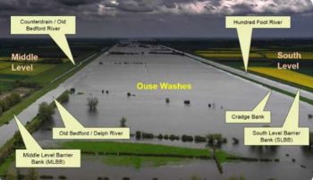
With a third of the Fens currently below sea level, the area has a network of flood protection assets that are owned and managed by different organisations. Much of this infrastructure is nearing the end of its design life and will soon need significant investment. With the increasing effects of climate change, flood infrastructure is key in providing water resources, environmental, navigation and wider amenity services.
The organisations involved in phase 1 either own or are responsible for the area’s flood risk assets, including:
- 138 pumping stations
- 4 sets of sluice gates
- 95 kilometres of coastal defences
- 405 kilometres of river embankments
Organisations involved in phase 1 include:
- Anglian Water
- Cambridgeshire County Council
- Ely Group of Internal Drainage Boards
- Environment Agency
- Middle Level Commissioners
- NFU (National Farmers Union)
- Norfolk County Council
- North Level District IDB (Internal Drainage Board)
- WRC (Water Resources East)
- Water Management Alliance
- WCIDB (Whittlesey Consortium of Internal Drainage Boards)
The baseline report is part of the first of the programme’s 3 main phases. Scenarios have been developed to describe the ‘do nothing’ and ‘do minimum’ approaches for the next 100 years across a huge geography of approximately 300 flood assets which are owned and operated by more than 40 risk management authorities. In this area, a third of land is currently below sea level and this will double by 2100 with rising sea levels.
Paul Burrows, Environment Agency spokesperson for Future Fens, said:
“The Fens is a complex environment that has been heavily engineered over hundreds of years. Understanding how the large systems of assets work together to provide protection from flooding is difficult and being able to articulate this to inform future flood infrastructure choices is even more challenging.
“That is why our early focus has been on ‘baselining’ and I am delighted that our collaborative report is now available and that ADA (The Association of Drainage Authorities) are hosting it on their website.
“This work showcases the flood infrastructure within the Great Ouse Fens, explores the economics of a do-nothing and do-minimum scenario and gives a high level overview of how current government flood funding policy would play out. It presents the initial asset management and investment challenge ahead.
“The next steps are to bring it to life through visualisation tools and develop the scope for the appraisal of the long-term choices for flood protection and resilience as climate change takes hold and society’s wider aspirations for the Fens become clearer.”
NFU – “important conversations to be had about funding gaps”
Rob Wise, the National Farmers Union East Anglia Environment Adviser, commented:
“The NFU has been pleased to be working with the Environment Agency and other partners on the Future Fens project given the vital national importance of food production in the Fens.
“Across the Fens as a whole the food chain is worth over £3 billion and employs 80,000 people. It is crucial that this strategic UK asset and the people who are part of it are protected from future flood risk.
“The project has already produced tangible benefits in suggesting new ways to value these assets to maximise government funding, but there are important conversations to be had about filling the remaining funding gaps identified in the report.”
Future funding - additional funding required from beneficiaries of flood infrastructure between £611m to £946m
To better understand the funding position, the project has looked at the Government’s Partnership Funding policy strategically and also worked with the National Farmers Union to create an improved approach to valuing agricultural land against the traditional method.
Key findings in the report are:
- £17.1 billion worth of benefits from the current flood risk management measures
- a further £5.3 billion of benefits to the local economy over the next 10 years
- £1.8 billion investment needed over the next 100 years to sustain the current standard of service from the existing flood risk management assets
To meet this level of investment there is an additional funding requirement from beneficiaries of flood infrastructure of between £611 million and £946 million, with eligibility between £722 million and £1.1 billion of government Flood Risk Management Grant in Aid funding (NB costs are present value.)
Next phases
The final elements of phase 1 will be to work with others to develop the scope for phase 2. Phase 2 will start to work on a long term adaptive plan for flood infrastructure in the Fens. This will build on the approaches outlined in the national FCERM strategy and appraise the flood infrastructure choices available for decision makers and prospective funders.
For the time being, tactical plans have been developed for the continued management of existing flood assets between now and 2031/32. These plans identify that around £230 million of capital investment is required.
Phase 2, which will evaluate options and choose the preferred strategic flood risk management approach, will take place between years 5 – 10. Phase 3, the planning and delivery stage, will take place between years 10 – 15
Click here to download the baseline report in full
Click here to download the baseline report summary document