Defra tenders multi million pound contract for Geospatial Enabling Programme Delivery Partner
![]() The Department for Environment, Food & Rural Affairs (Defra) has gone out to tender with a contract for a Geospatial Enabling Programme Delivery Partner with a potential total estimated value of up to £13.48 million.
The Department for Environment, Food & Rural Affairs (Defra) has gone out to tender with a contract for a Geospatial Enabling Programme Delivery Partner with a potential total estimated value of up to £13.48 million.
Lincolnshire Resilience Forum prepares for emergencies with digital twins and drones
![]() Lincolnshire Resilience Forum (LRF) has gone live with new geospatial technology from Esri UK to help it better prepare for emergencies across the county, including flooding, loss of critical infrastructure, pandemics or severe weather.
Lincolnshire Resilience Forum (LRF) has gone live with new geospatial technology from Esri UK to help it better prepare for emergencies across the county, including flooding, loss of critical infrastructure, pandemics or severe weather.
New Met Office climate data portal offers improved access to climate change data
 The Met Office’s Climate Data Portal went live yesterday, giving organisations improved access to climate data and other resources, allowing them to better understand and respond to climate change.
Geospatial Commission says new UK Geospatial Strategy 2030 will expand ground-breaking location data and technologies
 The Geospatial Commission has published the new UK Geospatial Strategy 2030 – the renewed Geospatial Strategy is intended to expand ground-breaking location data and technologies across the UK by 2030.
Geospatial Commission calls for new Land Use Analysis Taskforce
 A new Land Use Analysis Taskforce should be established to support decisions about how land in the UK is used, according to a new report from the Geospatial Commission.
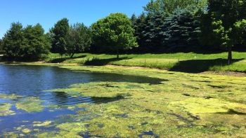
Anglian Water hidden leaks easier to spot during drought using drones to find and fix
 Anglian Water is carrying out innovative drone surveys around Ardleigh reservoir, Colchester, to identify difficult to find leaks and fix them - this year’s drought has presented an opportunity to spot leaks in a new way.
Northumbrian Water becomes first company to sign agreement to help reduce utility strikes
![]() Northumbrian Water has become the first company to sign a national data-sharing agreement as the NUAR (National Underground Asset Register) project is set to roll out across the country.
Northumbrian Water has become the first company to sign a national data-sharing agreement as the NUAR (National Underground Asset Register) project is set to roll out across the country.
UK Geospatial Commissions appoints Atkins to deliver UK-wide digital map of underground utilities
 Atkins – a member of the SNC-Lavalin Group – has been appointed by the UK Government’s Geospatial Commission to help create a digital map of underground pipes and cables which will revolutionise construction and development across the country.
Geospatial Commission launches next phase of project to map UK’s underground pipes and cables launched
![]() The Geospatial Commission has launched the next phase in the building of a digital map of underground pipes and cables today, described as “a step closer to revolutionising construction and development in the UK.”
The Geospatial Commission has launched the next phase in the building of a digital map of underground pipes and cables today, described as “a step closer to revolutionising construction and development in the UK.”
Geospatial Commission launches pilots to improve how data about land is used in UK
![]() Three pilots in Devon, West Midlands and Northern Ireland will test how to identify and improve key data that helps inform decisions on whether land across the UK is used for housing, infrastructure or net zero.
Three pilots in Devon, West Midlands and Northern Ireland will test how to identify and improve key data that helps inform decisions on whether land across the UK is used for housing, infrastructure or net zero.
News Showcase
-
Kohtari CEO says joined-up water intelligence needed to predict, not just react - not more data
 James Sumsion, CEO of predictive water intelligence specialists Kohtari, says the water sector needs to take a giant leap forward, so that it can anticipate and act upon water quality issues - rather than merely react.
 -
IED compliance – using automated sliding floodgates to support secondary containment at water and sewerage company sites
 Ray Moulds, Sales Director at Flood Control International, takes a look at how automated sliding floodgates are supporting secondary containment at water and sewerage company sites.
 -
Making storm overflow data make Sense – Metasphere launches dedicated monitoring device
 With the UK government demanding a 50% reduction in storm overflow spills by 2029, the era of reactive management is over. Speaking in the House of Commons on 21 July 2025, then environment secretary Steve Reed said, “This Government will cut water companies’ sewage pollution in half by the end of the decade.”
 -
King’s Award for Enterprise shows ERG moving forward with growth in UK and Asia
 ERG, the leading supplier of odour control systems and industrial gas cleaning & thermal systems, has been awarded the coveted King’s Award for Enterprise.
Expert Focus


News Sections
Other Latest News
- United Utilities awards £12 million AMP8 contract for mobile centrifuge and associated maintenance service operators
- North Ayrshire Council tenders £200k contract for general repairs & annual maintenance of Sustainable Urban Drainage (SUDs) installations
- Defra Secretary of State to face questioning by EFRA Committee on water sector, farming support and food security
- Defra - almost 20,000 new homes unlocked after breakthrough by government Water Delivery Taskforce
- Flood defence - EA begins ground investigations for £100m-plus Eastbourne and Pevensey Bay Coastal Management Scheme
- New report from S&P Global Ratings decodes data centre risk
Watch
-
Scottish Water completes £235m investment in two-way connection between drinking water networks
 Hear how Scottish Water has completed its £235 million Ayrshire Glasgow Resilience Project - customers across Greater Glasgow, Ayrshire and East Renfrewshire will now benefit from a more secure and resilient water supply.
 -
United Utilities accelerates investment to reduce spills from storm overflows across Northwest
 Hear how United Utilities is accelerating its investment to reduce spills from storm overflows across the Northwest.
 -
Working for WSP - what if you could build a career as unique as you? With us, you can
 Find out more about the remarkable career opportunities on offer at WSP - scroll down to watch the inspirational video.
Top Stories
- Defra Secretary of State to face questioning by EFRA Committee on water sector, farming support and food security
- Defra - almost 20,000 new homes unlocked after breakthrough by government Water Delivery Taskforce
- Anglian Water flags up procurement of upcoming c£35 million AMP8 Grounds Investigation Framework
Login / Register
New Account Registrations
To register for a new account with Waterbriefing, please contact us via email at waterbriefing@imsbis.org
Existing waterbriefing users - log into the new website using your original username and the new password 'waterbriefing'. You can then change your password once logged in.