
January rainfall, river flows and groundwater levels wwere below normal across much of England, according to the latest monthly water situation report from the Environment Agency.
 January was wetter than December across much of England, but rainfall totals remain below average in many areas. England as a whole received 81% of long term average rainfall for January.
Rainfall totals were below the long term average (LTA) for January in two-thirds of the hydrological areas. A number of hydrological areas in north-east England received less than 50% of the LTA rainfall for January, while parts of south-east England received more than 110% of the January LTA rainfall.
January rainfall totals were classed as normal for the time of year across south-east England, most of central and east England and parts of south-west England. However, across much of north-east, north-west and parts of south-west England, rainfall totals for January were below normal or lower.
The 6-month accumulations were the second driest August to January totals on record since 1910 in three hydrological areas. For the Teign and Torbay, this period was the driest since 1975/6, while for Dee and Upper Wye it was the driest August to January since 1933/4.
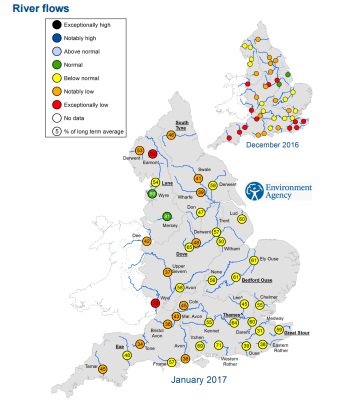
While river flows and groundwater levels increased at the majority of indicator sites, river flows were below normal or lower for the time of year at almost all sites across England. Groundwater levels were also below normal or lower at two thirds of sites.
Compared with December, monthly mean flows for January increased at the majority of indicator sites across England However, almost all sites were classed as below normal or notably low for the time of year.
Reservoir stocks increased at two-thirds of reservoirs groups and were normal or lower at all but one reservoir. Overall stocks for England increased marginally compared to the end of December and were 83% of total capacity.

